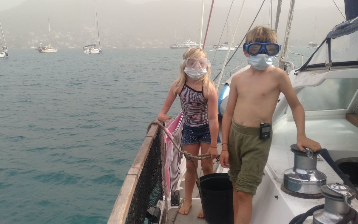
DANGERS 🌋💨 🌀 🌪️ 🏴☠️ ☣️🪸 ☢️ 📦 🌊
TSUNAMIS
TSUNAMIS
PRELIMINARY EARTHQUAKE PARAMETERS
---------------------------------
* MAGNITUDE 7.3
SAMPLE REPORT FROM UNESCO
* AN EARTHQUAKE WITH A PRELIMINARY MAGNITUDE OF 7.3 OCCURRED IN
THE TONGA ISLANDS REGION AT 1049 UTC ON FRIDAY NOVEMBER 11
2022.
* BASED ON ALL AVAILABLE DATA... THE TSUNAMI THREAT FROM THIS
EARTHQUAKE HAS NOW PASSED.
TSUNAMI THREAT FORECAST...UPDATED
---------------------------------
* THERE IS NO LONGER A TSUNAMI THREAT FROM THIS EARTHQUAKE.
RECOMMENDED ACTIONS
-------------------
* REMAIN OBSERVANT AND EXERCISE NORMAL CAUTION NEAR THE SEA.
OTHERWISE... NO ACTION IS REQUIRED.
POTENTIAL IMPACTS
-----------------
* MINOR SEA LEVEL FLUCTUATIONS MAY OCCUR IN SOME COASTAL AREAS
NEAR THE EARTHQUAKE OVER THE NEXT FEW HOURS.
* ORIGIN TIME 1049 UTC NOV 11 2022
* COORDINATES 19.3 SOUTH 172.1 WEST
* DEPTH 58 KM / 36 MILES
* LOCATION TONGA REGION
EVALUATION
----------
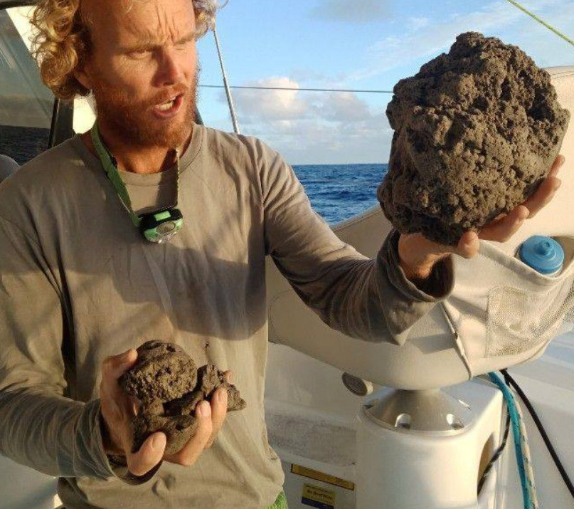
PUMICE
 SAMPLE REPORT
Report of Volcanic Rubble Slick dangerous to vessels.
Catamaran ROAM sailing to Fiji encountered volcanic
rocks (Pumice) completely covering the ocean surface at location:
18 55' S
175 21' W
Time 0800hrs UTC (1900hrs local) 15/8/19.
Rubble slick made up of rocks from marble to
basketball size such that water was not visible.
Description of event:
We had heard the previous day on email of "pumice
fields" 50NM North of Vava'u. We saw none as we rounded North of Vava'u earlier
in the day on our route ex Bora Bora.
Sailing on 255T we started seeing some floating
rocks of random sizes (marbles to tennis balls) from position 18 46' S 174 55'W.
We reduced sail to slow our speed.
At position 18 50' S 175 05' W we had faint but
distinct smell of sulfur. TWD = 115T at the time had us down wind of Home Reef
charted as area of volcanic activity.
We continued sailing at reduced speed on 250T.
At position 18 54'S 175 19'W we started to see and
strike larger floating rocks. We took down all sail. Allowing the boat to
continue on bare poles at 2-3kts on COG 255T. As we could no longer smell the
sulfur we assumed we would be soon clear of the rubble so elected to continue at
slowest speed.
At approx 0700hrs UTC (1900 local) 15/8/19 at
position 18 55' S 175 21' W we entered a total rock rubble slick made up of
pumice stones from marble to basketball size. The waves were knocked back to
almost calm and the boat was slowed to 1kt. The rubble slick went as far as we
could see in the moonlight and with our spotlight. We made a turn to starboard
and managed to sail clear of the rubble slick under Staysail. We had entered it
approx 200m and the edge could be made out in the partial moonlight back to the
NE. It was extensive in all other directions.
In the slick our steering became
temporarily/partially fouled by rocks jamming between rudders and hull.
Our speed log was also inturupted but thankfully
this morning both functioning as normal.
Once clear of the rubble we acted with caution and
retraced our course under 3rd reef main and staysail before turning south and
then west.
Other vessels in the imidiate area were notified and
we remained in touch to update one another on our status and that of the
conditions in our area.
My intention was to return to the East and sail
around the windward side of Home Reef and surrounding charted areas of volcanic
activity some 35NM to our SE. The two other yachts I informed of the rubble
slick found clear water going South and turning west from 19 00' S 175 05' W so
we followed them.
We have since cleared all sign of volcanic rock and
continuing to Fiji
SAMPLE REPORT
Report of Volcanic Rubble Slick dangerous to vessels.
Catamaran ROAM sailing to Fiji encountered volcanic
rocks (Pumice) completely covering the ocean surface at location:
18 55' S
175 21' W
Time 0800hrs UTC (1900hrs local) 15/8/19.
Rubble slick made up of rocks from marble to
basketball size such that water was not visible.
Description of event:
We had heard the previous day on email of "pumice
fields" 50NM North of Vava'u. We saw none as we rounded North of Vava'u earlier
in the day on our route ex Bora Bora.
Sailing on 255T we started seeing some floating
rocks of random sizes (marbles to tennis balls) from position 18 46' S 174 55'W.
We reduced sail to slow our speed.
At position 18 50' S 175 05' W we had faint but
distinct smell of sulfur. TWD = 115T at the time had us down wind of Home Reef
charted as area of volcanic activity.
We continued sailing at reduced speed on 250T.
At position 18 54'S 175 19'W we started to see and
strike larger floating rocks. We took down all sail. Allowing the boat to
continue on bare poles at 2-3kts on COG 255T. As we could no longer smell the
sulfur we assumed we would be soon clear of the rubble so elected to continue at
slowest speed.
At approx 0700hrs UTC (1900 local) 15/8/19 at
position 18 55' S 175 21' W we entered a total rock rubble slick made up of
pumice stones from marble to basketball size. The waves were knocked back to
almost calm and the boat was slowed to 1kt. The rubble slick went as far as we
could see in the moonlight and with our spotlight. We made a turn to starboard
and managed to sail clear of the rubble slick under Staysail. We had entered it
approx 200m and the edge could be made out in the partial moonlight back to the
NE. It was extensive in all other directions.
In the slick our steering became
temporarily/partially fouled by rocks jamming between rudders and hull.
Our speed log was also inturupted but thankfully
this morning both functioning as normal.
Once clear of the rubble we acted with caution and
retraced our course under 3rd reef main and staysail before turning south and
then west.
Other vessels in the imidiate area were notified and
we remained in touch to update one another on our status and that of the
conditions in our area.
My intention was to return to the East and sail
around the windward side of Home Reef and surrounding charted areas of volcanic
activity some 35NM to our SE. The two other yachts I informed of the rubble
slick found clear water going South and turning west from 19 00' S 175 05' W so
we followed them.
We have since cleared all sign of volcanic rock and
continuing to Fiji